Objective • Executive Summary
 Objectives Objectives
LEEMP is the result of Nigeria obtaining assistance from the International Development Association (IDA) and GEF to:
- assist beneficiary communities in participating states to have planned, co-financed and implementable environmentally sustainable and socially inclusive multi-sectoral micro-projects; and
- develop a set of verifiable indicators by synthesizing the essential baseline information for monitoring and evaluation of Project impact on the PAs and their support zones.
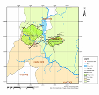
 However, the primary objective of the current study, as a component of LEEMP, is to collate baseline information on 60 communities in the six (6) LGAs that have been identified to participate in this Project in Bayelsa State. This baseline information is to broadly assist in providing an idea of the project impact based on a comparison of pre and post project situations in the LEEMP Communities. Another objective is to recommend monitorable indicators and means of verifying the indicators on the basis of prevailing environmental and social characteristics of the communities. However, the primary objective of the current study, as a component of LEEMP, is to collate baseline information on 60 communities in the six (6) LGAs that have been identified to participate in this Project in Bayelsa State. This baseline information is to broadly assist in providing an idea of the project impact based on a comparison of pre and post project situations in the LEEMP Communities. Another objective is to recommend monitorable indicators and means of verifying the indicators on the basis of prevailing environmental and social characteristics of the communities.
Executive Summary
See also:
 Data Collection, Groundtruthing and Collation Nationwide for the Enrichment of the Hydrological Information Systems for the Hydrological Mapping of Nigeria Project-HA1 Data Collection, Groundtruthing and Collation Nationwide for the Enrichment of the Hydrological Information Systems for the Hydrological Mapping of Nigeria Project-HA1
 GIS Mapping of Water Supply and Sanitation Facilities in South West Nigeria GIS Mapping of Water Supply and Sanitation Facilities in South West Nigeria
 Baseline Studies and Monitorable Indicators in and Around the Protected Areas Baseline Studies and Monitorable Indicators in and Around the Protected Areas
|